Some thoughts on the Roman occupation
of the Fylde and Over Wyre
David Horrocks
Lancaster and Iter X
The Roman fort at Lancaster was occupied throughout most of the Roman period. It went through several refits until it was rebuilt in the fourth century in the style of the Saxon Shore forts. It is almost unthinkable to me that this obviously important installation was omitted from all of the ancient sources, as is currently thought. I have always liked the obvious connection between the name Alone and Lancaster. This connection showed up in Britannia several years ago, and a very strong argument was put forward for placing this station at Lancaster. If we look at the distances in Iter X of the Antonine Itinerary, we see that Alone is 18 or 19 Roman miles from Calacum, which is 27 Roman miles from Bremetennacum. Bremetennacum is firmly fixed by inscription to Ribchester, and Calacum is usually proposed as Burrow, but the distances between these stations don't quite line up. I was searching for another possibility, and came up with the thought that nobody has ever followed the other possible route for this 27 mile trek (a rather long spacing for Roman installations.) The only other known road that this station could be on was the road that led into the Fylde from Ribchester. The installation at Kirkham had long been abandoned by the time that the Itinerary was written down, so the fact that the route had to pass by Kirkham unnoticed was not troubling to me at the time. For Calacum to be somewhere in the Fylde, and Lancaster to be the Alone of Iter X, there needed to be a road from Lancaster directly into the Fylde. I remembered reading about a trackway in the Over Wyre district in Watkin's "Roman Lancashire," so I started to research it. I have since abandoned the idea that Calacum was in the Fylde, but the search led me down an interesting path:
Watkin's Road
Watkins' road:
"A very peculiar wooden pathway is the only other road to be noticed. It occurs on the eastern bank of the Wyre, about four miles east of Fleetwood, and is traceable in a straight line through Pilling and Stalmine Mosses, between Pilling Hall and Hales Hall. Like the road from Ribchester to the Wyre, it is named "Danes Pad." It is formed of large oak trees sawn asunder, in some places of one large tree, and in others of several. These are laid upon sleepers, to which they are fastened by wooden pegs, which are driven through them into the peat beneath. The average width is twenty inches, and the road is now several feet beneath the surface of the moss. It is rapidly disappearing, from modern inroads upon it. The origin of the road is lost in obscurity, but as Roman articles have been found in the adjoining mosses, it is conjectured that it may be as ancient as the Roman period, though it is quite as likely that it may be of mediaeval origin. At the supposed termination of this road is a field completely full of round holes, somewhat similar to the "Penpits" in Somersetshire. The road may possibly, therefor, be British,and may have led to a British village."
Now, this road has recently come under some scrutiny by the North West Wetlands Survey, and was deemed to have been British in origin. This effectively eliminates any argument claiming a Roman connection before it even starts, right? Maybe not; if one looks at the relevant section of the survey:
"These previous records suggest that there were three separate structures present in Stalmine Moss, one to the north of Friar's Hill, excavated in 1949 - 50 and two, possibly three, to the south. The latter were well-built using elaborate construction techniques, whereas the former was informal in nature and its mode of use somewhat problematic as it would have been difficult to walk on, particularly across a wet mire. There can be little doubt that the southern trackway(s) have been long removed by peat cutting, the last segments being cut away in the 1920's. No evidence for their existence was found during the present survey. Around the more northerly trackway, however, several areas of deep peat still survived and the opportunity was taken to investigate the trackway further using modern methods to answer a number of new questions."
So, in essence, we have no proof one way or the other as to the nature of the elaborately built causeways and, therefor, they could be of Roman origin. It would certainly be Roman to build them well. We have a reference to Roman roads of this type built in Northern Britain from the historian Herodian:
"In particular he attempted to divide up the marshy districts with causeways so that his men by running along them without difficulty could advance in safety and then have a firm footing on a secure platform while they were fighting. ...A thick mist rises from the marshes, so that the atmosphere in the country is always gloomy. It was for these conditions that Severus got ready what was suitable for the Roman army, and likely to damage or impede a barbarian attack."
This is, of course, in reference to the preparations for the invasion of Scotland in 208AD, as it appears in the section of the text that discusses the preparations for the Severan invasion. One may wonder why they would build causeways prior to invading, but it clearly precedes the actual invasion in the text. The application of this tactic must have been broader and based on a successful model from other marshy areas, such as Over Wyre. In my opinion, this passage should not be viewed in isolation.

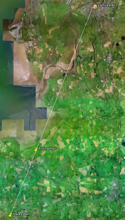
Click to Enlarge | Perhaps the most convincing argument for this road's possible Roman connection is the route itself. This route is not the shortest way across the marshes, so why did the builders choose this path? If we trace the route from Hales Hall to Pilling Hall, and continue on this line, we find that it is heading directly, and unerringly, for Lancaster, and not only Lancaster in general, the Roman fort in particular. This may, of course, be a coincidence, but it is a remarkable one if it is. This route passes Cockersand Abbey near where two statues (RIB 616, 617) dedicated to Mars Nodens were found. These statues were apparently of the type typically found in roadside shrines and, as this area was some distance from the main Lancaster to Walton road, the possibility of another road exists. Another interesting point is that the proposed route heads for Kendal Hill as it passes Cockersand Abbey. During the Roman period, the course of the river Lune would probably not have crossed this path, and the coastline in this area has since changed much due to erosion. This route may well have been over dry land all the way from Pilling Hall to Lancaster. |
So, is there any evidence of pre-Severan interest in Over Wyre and in this route in particular? Well, yes there is, sort of, if one looks at the coin loss evidence for the second century, as found in David Shotter's book "Roman Coins From North West England." This may only be a reflection of modern activity in this area, but it is extremely tempting to see it as a pattern, as most of these coin finds are just to the west of our route. This may indicate that our route served as a form of barrier.
| 
Click to Enlarge |
If the Over Wyre area was an unpopulated bog, why were the Romans active here during this period? Another quick consultation of the North West Wetlands Survey reveals some rather startling facts. The pollen analyses indicate somewhat drier conditions than currently exist, and:
"Thus, whilst the artefactual record for Romano-British settlement in the area is lacking, there are a number of factors which suggest that, if Over Wyre was heavily settled, it would still be difficult to detect archaeologically."
My main point is that we know next to nothing of the native population in this area during the Roman period, and any statements regarding it are purely conjectural. So, one must now ask, "are there any other clues that may indicate that this area was more populated than is currently believed?" The answer is, once again, yes... sort of; for approximately 40 years, the Romans felt it neccessary to have a fortress made of stone in the area.
The Problems with Kirkham
I have long puzzled over the Roman fort at Dowbridge, as it appears to be somewhat of an enigma in the chain of forts in the NW. The siting of the fort gives the impression that it is there for defensive purposes, but the dating of the site points to a purpose related to invasion and control. If the area posed no threat to the Romans, and it was merely used as a drop off for troops heading elsewhere, why not just leave it as a camp? And why put it on the hill? Even if the sea level during the period was high enough to flood Freckleton Marsh, it is still two miles from the marshes closest point. Where else in Britain do we have another example of an entrepot this far from shore? The longest lived installation on the site was a feature variously interpreted as a signal tower, a watch tower or a lighthouse, that was incorporated into the later stone fort. If this was a signal tower, to whom were they signalling? The site is too far from the nearest known sites to act as anything but a beacon-type signal, any coded signalling would have been impossible between them. Of the known Roman lighthouses, although data is somewhat hard to find, none appear to be this far from shore, it is five miles from the sea at it's closest point. If it was simply a watch-tower, and if the Fylde was as uninhabited as has been proposed, whom were they watching? And why keep it around after the stone fort was built? Indeed, the present interpretations of this site leaves us with more questions than answers.
The other odd thing about this site is the dating of its abandonment. It appears that the fort last saw use in the 160's, a time when other forts in the area, Ribchester, Lancaster, Watercrook, etc. show clear signs of being refurbished and re-garrisoned due to the withdrawal from the Antonine Wall. Indeed, we see the Dowbridge fort in a state of decline even during the turbulent time of the Brigantian revolt of the 150's. Why go to the trouble of constructing a stone fort, yet not use it during a time when it was needed, especially if it was an entrepot for troops serving in Western Brigantia. It must, therefor, have been deemed redundant or unnecessary. Of these two options, redundancy seems the more logical, as a site that was important enough to warrant the construction of a stone fort in the 120's, as part of the garrisoning of the Hadrianic system, seems unlikely to be unnecessary in the 160's during the re-garrisoning of that same system.
Most people avoid dealing with this station when they discuss the Roman occupation of Lancashire. Even David Shotter barely gives it a nod, without any interpretation, and the NW research framework (that you were kind enough to send over) only summarizes the phases of the fort; they don't mention it in the discussions. Interpretation is extremely difficult, as very little about this site makes sense.
The road to Fleetwood
The existance, if not the exact route, of the road from Kirkham to Ribchester, and beyond, is well known from antiquity. It was also thought that this road continued west from Kirkham to a port or other installation offshore from Fleetwood. According to Thompson, this road carved a gentle curve across the high ground in the Fylde. A gentle curve doesn't sound very Roman, does it? When the NWWS went looking for this road, they came up entirely empty-handed. They looked in the most likely spots for this road to have been, but didn't turn up any evidence of road material. This seems quite unlikely if this road did exist. So, if this road didn't exist, we end up with a road that starts in Kirkham and travels east towards Walton and Ribchester. If this was the case, Kirkham becomes the only fort in the north of England with only one line of communication. At first glance, Ravenglass appears to be in the same predicament, but it was a fleet base and the coastal road surely went at least that far.
So, Kirkham stands in extreme isolation, at the terminus of a road, miles from the river and its associated harbour, in an area where this was obviously considered by the Romans to be unacceptable. All installations have at least two lines of communication via the road system, and Kirkham cannot be an exception. If the road to Fleetwood didn't exist, there must have been another road... right?
One further note on the supposed installation at Fleetwood: This seems an unlikely spot for the Romans, if one looks at the siting of all of the other installations in the North-West. It seems to me far more likely that this site, and the masonry found offshore, is a light-house. This spot is an excellent position for one, as evidenced by the existence of the modern lighthouse at Rossal Point.
Another road?

Click to Enlarge |
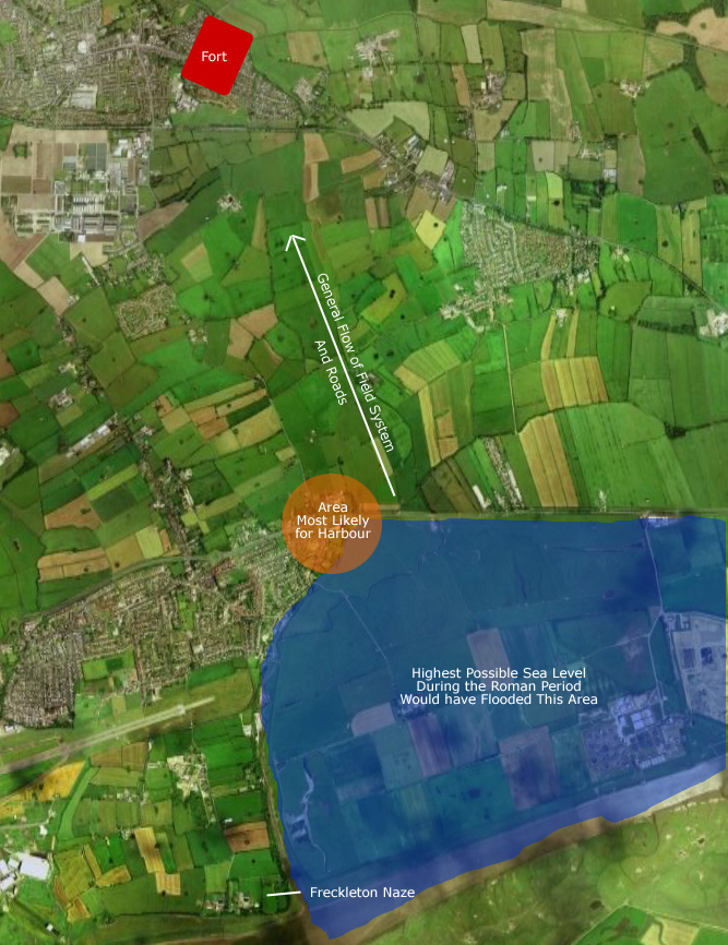
There is an antiquarian report of a hypocaust found at Freckleton Naze. This report has encouraged many enthusiasts in their search for the supposed harbour below the Kirkham fort. Many have looked, but no evidence of road, nor harbour, has been found since. There must surely have been some sort of landing place in Freckleton Marsh, or Kirkham's fort becomes even more strange. If we look at the area, we can immediately conclude that the Naze is the wrong area to be looking. It may make a reasonable place for a lighthouse, but not so good for bathhouse or harbour. The Naze is on relatively high ground, so water supply would have been tricky compared to the lower ground near the crook of the marsh where the brook enters the marsh. As a harbour, it would provide inadequate shelter, whereas the crook provides as much shelter as can be had in this area. It is also apparent that the fields and roads seem to flow in the general direction of the fort on Carr Hill. A quick glance at the first edition OS maps show that these fields have not changed much.
|
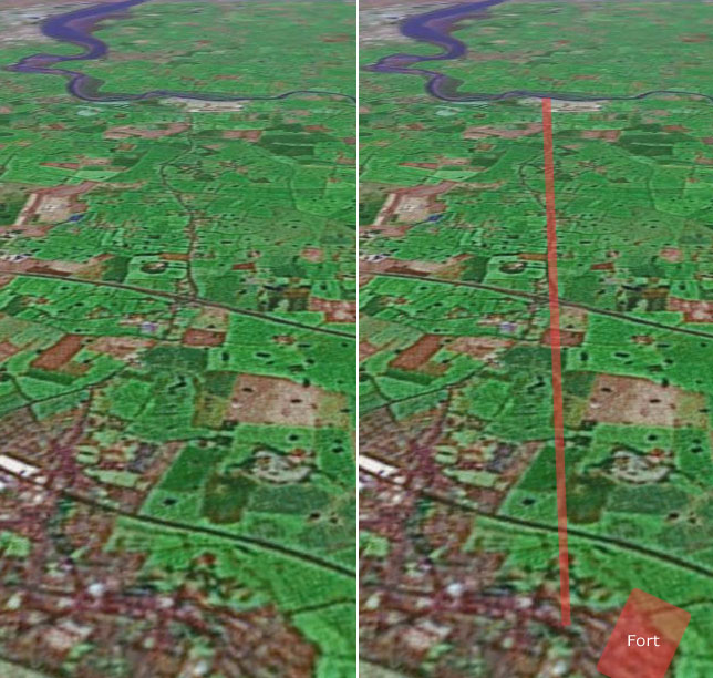
| If one carries that direction forward, past the fort at Kirkham, and into the Fylde, a line of features becomes apparent. Granted, this is superficial, but a line does exist and seems to connect a series of high places on a route that changes direction slightly as it crosses the Wyre and heads directly to Knott-End-on-Sea. This gives the impression of a connected line of high places, ideal for a signalling system, with Kirkham at one end and Knott End on the other. Interestingly, this alignment is very similar to both the alignment of the route from Manchester to Ribchester, and the route from Wigan to Lancaster. |

Click to Enlarge |

Click to Enlarge |
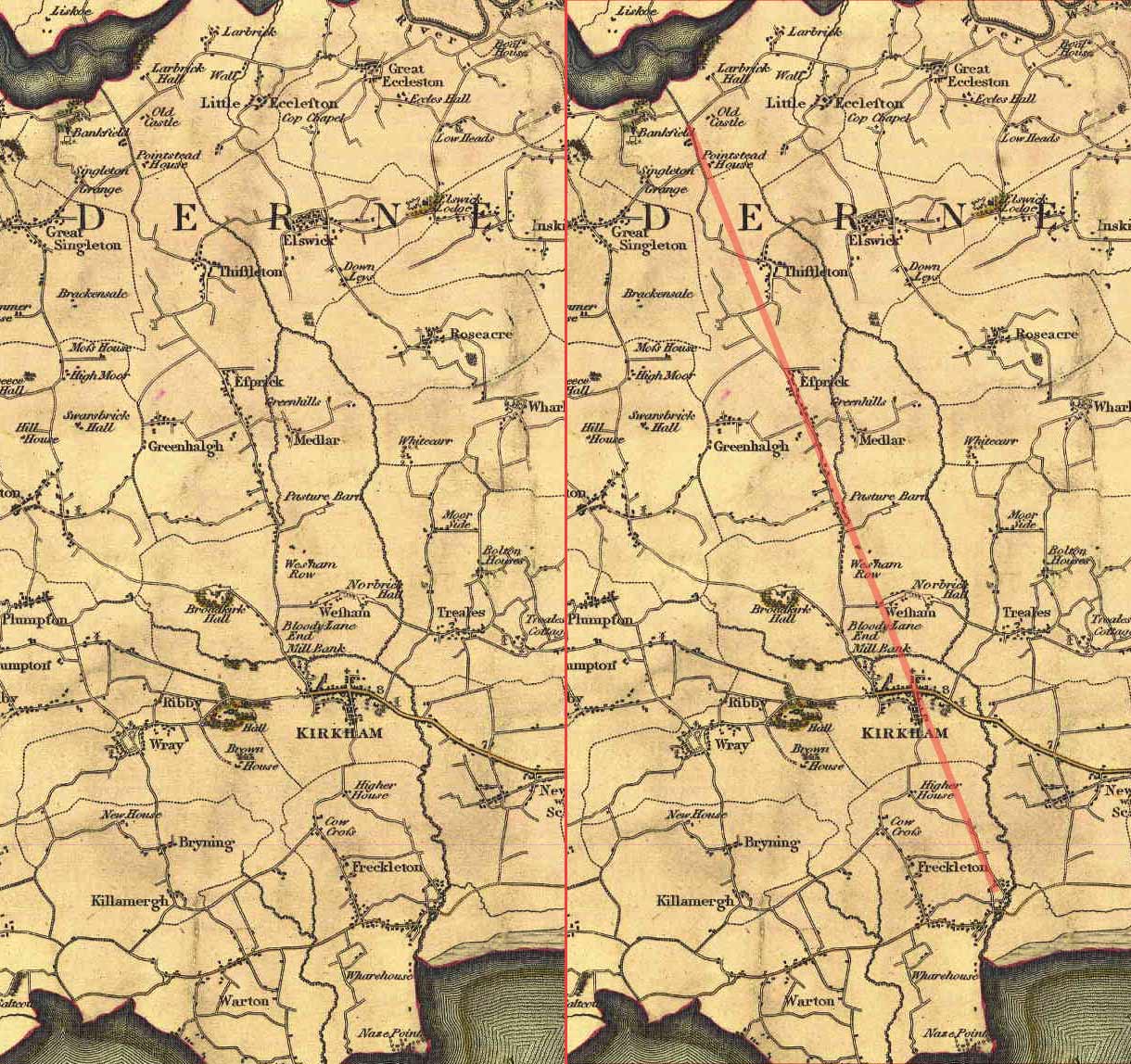
One of these features, the A585, is modern, but if we have a look at some of the earliest maps of the region, we quickly see that the A585 was built mainly upon the route of previous roads. This map is not entirely accurate, but it clearly shows the route has several sections on the same alignment. It doesn't show up on this map, but there is even a street in Kirkham that is on this alignment, contrary to the alignment of all of the other streets in Kirkham. If this is indeed part of a Roman road, it passes just to the East of the church, which would seem to make sense, as this would have been one of the early churches in the area. |
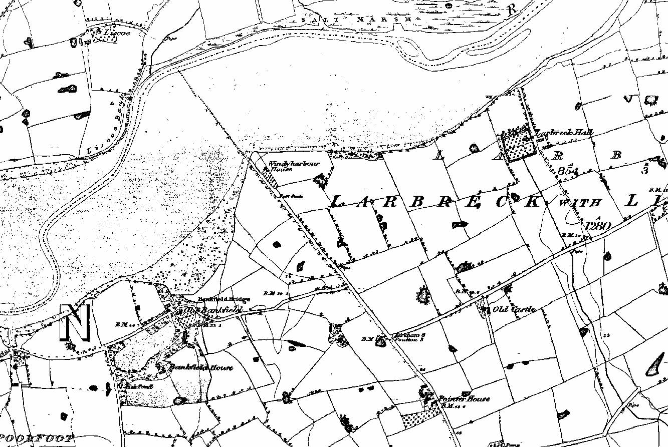
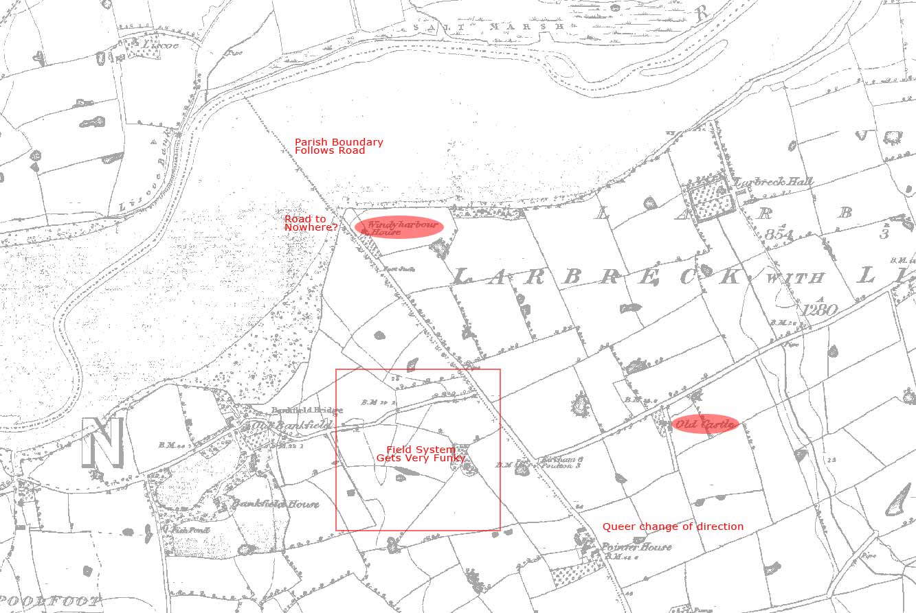
| If we have a look at the area where this route would cross the Wyre, we see that there are a number of interesting items. The first is the Windy Harbour Holiday Centre. Windy Harbour is a place name that has long been associated with Roman roads, but this place is modern, surely. When one looks at the first edition OS map, Windy Harbour House occupies the spot of the current holiday centre, indicating this name has been associated with this spot for a long time. Other place names in the region include two Eccles names, Great Eccleston and Little Eccleston. Eccles is a name that is indicative of an early Christian church, and these places usually show up a mile or two off of Roman roads. It would seem that the builders wished to avoid bands of marauders that would use the old Roman roads as a means of hasty travel. One also notices the place name Old Castle. I have been unable to find out any information on this place, other then the fact that it was called that on all of the maps ever produced of the area. Which 'old castle' that it is referring to is uncertain, but the name is interesting. |

Click to Enlarge |

Click to Enlarge |
Another interesting feature of the OS map is the change in course of the road. There doesn't appear to be a good reason for this shift in alignment until you look at the other side of the Wyre. It would appear that, if this route is intending to cross the river, the builders were avoiding the salt marsh on the other side. The route heads to the point of land at Windy Harbour and passes the house, to abruptly end at the edge of the river, giving the impression of a will to continue across. The parish boundary follows the route of this road, which was common with Roman roads and, even if this parish boundary is a later one, it is indicative of a sense that this route was viewed as the edge of something. There is also a curious anomaly in the orientation of the field system in the area.
|
The River Wyre
Fort placement was a source of pride for the Romans, as the following passage from Tacitus' Agricola shows:
"He would himself choose the position of the camp, himself explore the estuaries and forests... garrisons and forts were established among them with a skill and diligence with which no newly-acquired part of Britain had before been treated."
As a note of interest, this section of the Agricola (20) is accepted as a direct reference to the conquest of Lancashire and Southern Cumbria.
Agricola's prideful placement of the camps and forts may be a source of information for us. If we latch on to the estuary comment and have a look at the placement of the river based installations in the North West, we can see a correlation between placement and tide. Whether or not these were all Agricolan installations is irrelevant, as it is indicative of Roman military planning.
| Major River |
Tidal Limit |
Connected Site |
Tidal Limit to Site |
Estuary to Site |
| Dee |
Just upriver from Chester |
Chester |
~ 1km Downstream |
12 km* |
| Mersey |
Just upriver from Wilderspool |
Wilderspool |
~ 2km Downstream |
11 km* |
| Ribble |
Just upriver from Walton |
Walton |
~ 1km Downstream |
12 km |
| Wyre |
Just below Little Eccleston |
--- |
--- |
--- |
| Lune |
Just upriver from Lancaster |
Lancaster |
~ 2km Downstream |
8 km |
| Kent |
Levens Park |
Watercrook |
> 4 km Upstream |
16 km |
* Both the Dee and the Mersey have strange estuaries. The Dee has been measured from where it gets wide enough, and tidal enough, to be considered sea. The Mersey measurement was taken from Runcorn Gap.
Now, as we look at this table, there are two anomalies. The first we will deal with is the river Kent and its connected fort, Watercrook. Why would this fort be so far upstream from the tidal limit, when all others are below theirs? If we look at the area around Levens Park, we immediately come upon the town of Hincaster, one of very few caster/chester names in Britain without a known Roman connection. For Hincaster to have no Roman connection is unimaginable, and to quote TW Potter:
"In the Hincaster/Levens area, 4-5km to the south of Watercrook, considerable quantities of Roman finds have been made. Just to the north of Hincaster (whose name is suggestive of Roman activity), motorway construction brought to light large quantities of second-century samian, ranging in date from Hadrian to c. 200 (Potter 1975). There are also finds of coins from Levens (J. Marsh pers. comm.) and, in Levens Park, a complex sequence of features of prehistoric, Roman or early medieval date (Sturdy 1972, 1973). The long lived tradition that Levens was the site of a circular temple to Dianna appears to have little factual evidence to support it: but there is Roman material from the area (much of it from still unpublished excavations by Sturdy), including a very fine carved jet figure, seated and in a pose of mourning. This is supposed to have been found with a coin of c. 330 (Munby 1975). Taken together, the volume of Roman finds from the Hincaster/Levens region certainly is hard to explain purely in terms of native settlement: this concentration is much more likely to reflect Roman activity. What form this activity took - religous or military, or probably both - is impossible to decide without further data. In a strategic sense, Hincaster would have been as appropriate a setting for a fort as Watercrook itself, and it is not unlikely that a fortlet or signal station was placed there."
So, if we accept a site at or near Hincaster as a distinct possibility, the table now looks like this:
| Major River |
Tidal Limit |
Connected Site |
Tidal Limit to Site |
Estuary to Site |
| Dee |
Just upriver from Chester |
Chester |
~ 1km Downstream |
12 km* |
| Mersey |
Just upriver from Wilderspool |
Wilderspool |
~ 2km Downstream |
11 km* |
| Ribble |
Just upriver from Walton |
Walton |
~ 1km Downstream |
12 km |
| Wyre |
Just below Little Eccleston |
--- |
--- |
--- |
| Lune |
Just upriver from Lancaster |
Lancaster |
~ 2km Downstream |
8 km |
| Kent |
Levens Park |
Hincaster area |
~ 1km Downstream |
10 km |
The only anomaly left is the river Wyre. Would the Romans have left this undefended, the perils of which are evident from the Scandinavian invasions from later centuries, in favour of the site at Kirkham? Especially during the later years, long after Kirkham had been abandoned, when there were problems with the Scottii and Attacotti looking to get a foothold in Britain? Personally, I find this a little hard to believe (especially if, as has been proposed, the Romans were using the Fylde to raise horses) and, when I tied all of the clues together, I found, what I thought was, a likely site for an installation of some sort.
A Possible Site
If there was, indeed, a site on the river Wyre, it should be somewhat down river from Little Eccleston, if we follow the connection with tidal limits, and 8-12 km from the estuary (probably more like 8-10 km, to be in keeping with the other Morecambe Bay estuaries.) It would also be connected to the other installations with some sort of road system.
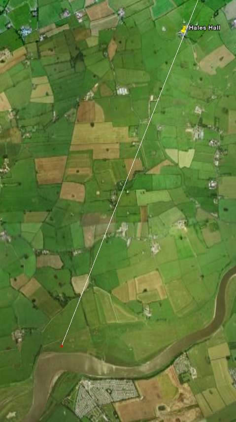
If we trace the proposed route from Lancaster, across the Pilling and Stalmine mosses, past Hales Hall, we see that the line reaches the river Wyre across from Windy Harbour, exactly the same point as the proposed route north from Kirkham. The Windy Harbour area is 8 km from the estuary and approximately 3 km down river from the tidal limit.
|

Click to Enlarge |

Click to Enlarge |
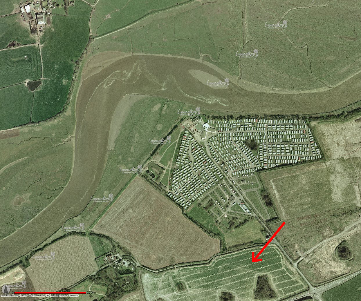
In an attempt to see if this was a good fording spot, I called up an aerial photograph of the Windy Harbour area, I was shocked to see, what appeared to be, the outline of a fort or camp. This is placed at the proper location to guard a ford of the river at the convergence of these two routes. It is in the area, and seems to be central to, where the field alignment gets very strange on the OS map. Careful measurements of the photograph revealed that the enclosed area is almost exactly the same size as the fort at Ribchester (5 acres), which is quite a coincidence. |
Problems with this photograph have been put forward, and they include:
- The two visible corners, although curved, appear to be of different sizes. Personally, I have a very hard time defining the north west corner and, therefor, can't agree or disagree.
- A lack of visible entrances.
- The lines in the interior are most probably a drainage system, and as they seem to be contained within the outline, would indicate a possible field system. Indeed, on the first edition OS map, the outline is followed somewhat by a fence or path. This, of course, is not the end of the world, as field systems have followed Roman boundaries at other locations.
- On the south-west side of the outline, when the line enters the copse of trees, it exits at a slightly different alignment.
- One strong concern for me is, if the drainage system is modern, why was nothing found when they installed it?